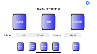
Avalon Offshore is a complete weather routing and navigation application . It works on iPads and iPhones. It also works on the new generation of Macbook Air and Pro,equipped with an ARM 64 chipset. Avalon Offshore integrated the whole set of functions that are useful to cruisers and offshore racers; weather routing, weather, navigation with NMEA 0183 and AIS collision alarm, anchoring alert, regatta start management wit laylines, etc… Avalon includes automatic loading of 65 weather models: NOAA GFS, Metro France Arpege,and Arome, DVD Icon, OpenWRF Skiron, etc Avalon also includes advanced functions such as: - Bathymetric weather routing, allowing calculation of routes taking into consideration the draft of the boat. - Simultaneous comparaison of routes across different weather models, different routes options, etc… - Free use of Avalon VPP to calculate customised VPP polars for single hull boats (main sail + genoa, code 0, gennaker, spinnaker, staysail and mizzen sail. - High compression of weather data on several models (GFS, Arpege, Icon, NAM Caraïbes et USA East) enabling to reduce by up to 95% volume of data, very efficient for satellite transmission (Iridium Go, Iridium Inmarsat, etc) - Easy weather routing module (from harbor to harbor) for a quick start of the app. - Compatible with ©Navionics Boating maps without additional cost. - Interfaced with ©Navily for a quick selection of the best moorings and harbors. - On time arrival : Calculate departure time to arrive on a given time - Compatible with ActiveLook® Augmented Reality glasses VPP Polars - Free use of Avalon VPP to customize your boat velocity preduction and adapt them to the exact caracteristics of your boat - Polar captation at sea Nautical Maps - Free raster nautical maps: NOAA, Linz, Brasil, New Zealand - In-app pack of maps derived from UKHO or SHOM covering France, UK Belgium, Portugal, Spain Carribean, Eastern and Western Mediterranean, Transatlantic, ... - Personal maps support: mbtiles, tif, kap, geotiff - Navionics maps: You can use your Navionics Boating maps with Avalon free of charge. Weather Sources - 65 automatic weather sources (wind, gust, current, wave and general weather) included in the Premium Option (in-app purchase) - Capability to load external grib files (as an alternative to the Premium option) - Capability to load external current grib from Tidetech® Includes one month free use of Premium options (see below) IN-APP PURCHASE: PREMIUM OPTION Includes: - Iridium data compression (reduce by 6 transmitted volumes) - additional weather sources: Arome, Arpege, NAM, CEP, Skiron .... - Weather data up to 394 hours including Wind, Gust, Waves, Precipitation, Storms, Cloud Coverage, Pressure, Temperature - Integration of currents in route calculation in covered areas (worldwide, Iberia Biscay and Ireland and Mediterranean sea) - Waves (Swell and wind waves) Privacy Policy and Terms of Use at: http://www.avalon-routing.com/new/privacy/ Warning: Continued use of GPS running in the background can dramatically decrease battery life. Policy and Terms of Use at: http://www.avalon-routing.com/new/privacy/