Blue Ridge Pkwy Travel Planner

Blue Ridge Pkwy Travel Planner

By Blue Ridge Parkway Association

  • Category: Travel
  • Release Date: 2012-09-27
  • Current Version: 3.5.5
  • Adult Rating: 4+
  • File Size: 73.50 MB
  • Developer: Blue Ridge Parkway Association
  • Compatibility: Android, iOS 12.4
Score: 4.57817
4.57817
From 742 Ratings

Description

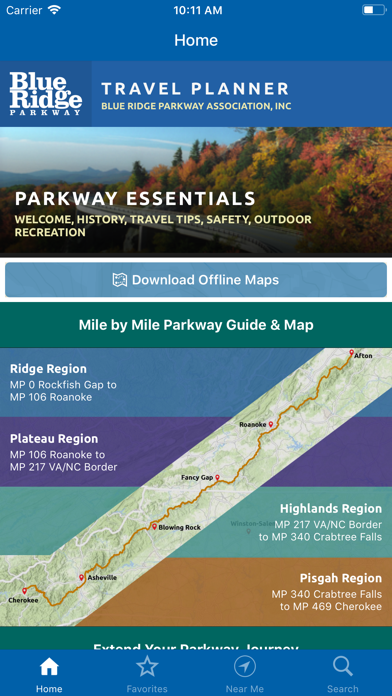
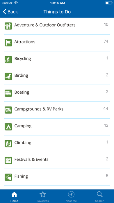
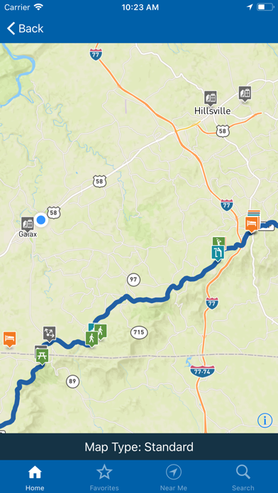
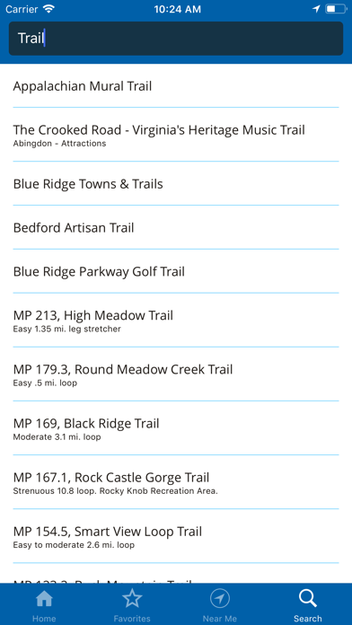
“America’s Favorite Drive” at your fingertips. 469 miles of scenic places, historic sites, trails, overlooks, interpretive exhibits, visitor centers, lodging, services, and essential information for visiting the Blue Ridge Parkway area. Brought to you by the Blue Ridge Parkway Association in cooperation with the Blue Ridge Parkway, National Park Service. BRPA has been serving visitors since 1949 as an official partner organization of the Blue Ridge Parkway dedicated to providing tourism and hospitality information to the Parkway traveler. Access detailed information for the Parkway’s four major regions Ridge, Plateau, Highlands and Pisgah as well as information for connecting regions including the Great Smoky Mountains National Park region (located near the Parkway’s southern end) and the Shenandoah National Park region (near the Parkway’s northern end). Explore by region, activity, or by proximity to your location. Download the app to your phone to access content with or without a cell signal during your trip to visit the Blue Ridge Parkway area, or use it to plan your vacation before you leave home. Features include: - Maps and navigation guides - Parkway visitor centers - On and off-Parkway campgrounds & lodging - Interpretive stops on the Parkway - Gas availability and travel information - More than 50 popular hiking trails - Suggested itineraries - Major access points for the Parkway - Adjacent Parkway communities and services - Wildlife information - Special events - Save places to your Favorites list - Use your GPS signal to explore nearby points of interest This free mobile application is published by the Blue Ridge Parkway Association to help you more fully enjoy your Parkway area vacation. Our members include attractions, outdoor recreation sites, accommodations, restaurants, shops, and a variety of other services essential to the traveler. This mobile application does not imply endorsement by the National Park Service of the businesses or commercial services listed. When you visit their place of business, please let them know you found them in the Blue Ridge Parkway Travel Planner mobile application. This will help us ensure the future availability of this application for visitors to the Parkway area.

Screenshots

Reviews

  • Offline maps!

    3
    By Franktafl
    I tried to reach app support on this issue but the page is not available so I guess I’m on my own. I purchased the offline maps for 1.99. Not complaining about that but I purchased it on my iPad and also loaded it on my phone. It keeps asking me to purchase the offline maps and the app still has the purchase option there. Seems like everyone here has an issue with the offline map stuff. Otherwise, the app itself seems to work ok. Not sure if the app support is available and not sure who the 1.99 payments are going to. Must be nice to be able to get paid and not support the product…
  • So far so good!

    5
    By Flimflam670123
    Works as advertised!
  • Found this worthless

    1
    By JunkY software
    Hard to use and didn’t provide much of the promised features
  • Great planning tool!

    5
    By Woodfrey
    I am still making plans for our RV trip along the Blue Ridge Parkway and this app has a wealth of information! I Can review and chose which stops and attractions we want to visit along the way as well as get information on campgrounds to call for reservations. I can’t wait to get started traveling on it. Thank you for developing this amazing app!!
  • Buy this app and get unlimited junk Mail

    1
    By ghuffer
    I bought this app 2 months ago and the junk emails have not stopped. Update. I bought this app 8 months ago and I’m up to 200 junk emails a DAY. Just get the free map from a ranger/visitor centers.
  • Blue Ridge Parkway

    5
    By CareyMelvin
    I went to the Blue Ridge in May and I struggled with no cell service, not being able to find a hotel, etc. This app looks like it is very helpful.
  • Useless as a mapping tool

    1
    By picree
    First tried to get to Access Point Switzerland (330.9). The app left us 60 minutes away. Decided to switch to an access point north of Marion (344.1). The app dumped us in Marion 30 minutes away. Had to ask for directions at the library. The map in the app looks like an old USGS map with only random city names and mostly unmarked squiggles for roads. No way to figure out where the heck you are in the mountains. The app really is just a list of some of the things you might see on the pkwy (some of them might have markers on the pkwy, some may not, and some things on the pkwy aren’t in the app). Oh - and the app doesn’t work offline even if you pay for offline maps. Another oh - and the app hasn’t been updated in over a year. Basically a dead app at this point.
  • Didn’t Work Offline

    2
    By JN0nick
    Although an option to purchase offline maps exists (and I bought it), the app didn’t work without a signal. Open opening, the app would only attempt to update itself without moving on. It could not update without a signal, which happens a lot out there, which is why I paid for the $ add on. The app would just sit there, useless, while trying to update itself with no signal. Frustrating and a total waste of time in remote parts of the Parkway.
  • This is awesome!

    4
    By KKuder
    Very nice tool to have on the parkway. Been needing this for a very long time.
  • Favorites

    2
    By Am mould
    Why is there not an option to see all my favorites marked on the map? That seems pretty basic to me.

keyboard_arrow_up